The Connecticut River
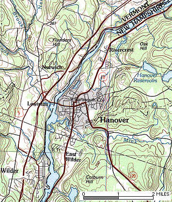
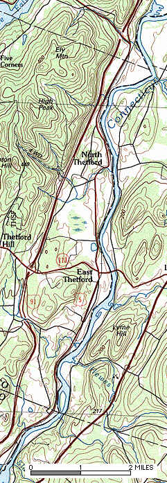
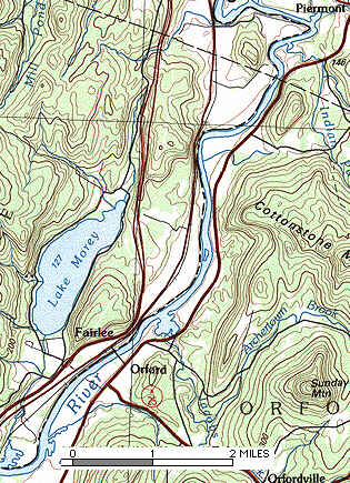
Maps: ... Norwich-Hanover ... Thetford-Lyme ... Fairlee-Orford
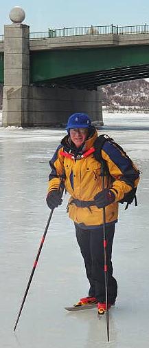
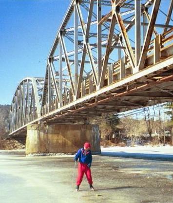
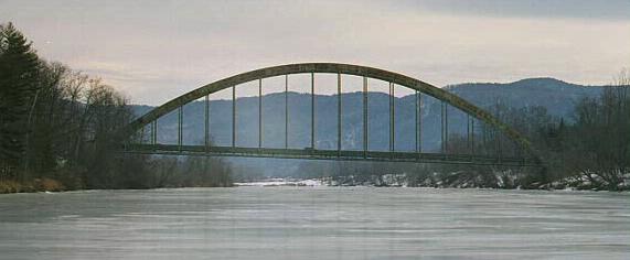
For 200 miles, the Connecticut River forms the boundary between the states of Vermont and New Hampshire. It's a working river, with hydroelectric dams generating much of the electricity used in the region. One of these dams is Wilder Dam, located just north of White River Junction, Vermont and West Lebanon, New Hampshire. The impoundment behind the dam is narrow and very, very long. In 40 miles of flat water upstream of Wilder Dam, the river is rarely more than a hundred yards wide, yet it is crossed by only four bridges. The river is flanked by tall forests, old farms and quiet villages, with mountains rising behind them. In the winter, when the weather cooperates, the Connecticut River freezes into a broad highway that entices you to explore as far as your physical ability and the abbreviated daylight hours will allow.
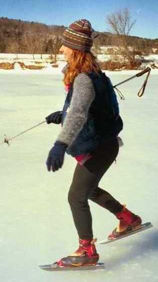
The Montshire Skating Club organizes tours on the river every winter when the ice is good ... which can be any time between mid-December and mid-March. The best skating conditions in recent memory were in February 2001 when it was possible to skate 35 miles from Wilder Dam upstream to Bedell Bridge State Park (between South Newbury, VT and Haverhill Corner, NH). In a more typical winter, good skating is restricted to a 10-mile strip between Hanover and Lyme, NH. Even so, after a 20-mile round trip, we don't hear many people complaining that they didn't get enough miles in. If they did complain, we'd just tell them to go out and skate the same 20 miles again.

Ledyard Bridge, Norwich, Vermont
At 7:30 AM on a crisp, still morning, I sat on a riverside bench at the Ledyard Canoe Club on the edge of the Dartmouth College campus. I clipped into my Nordic Skates and stepped carefully down onto the steel-gray ice. It was solid, smooth and remarkably free of cracks and air pockets. Aiming my skate blades upstream, I accelerated quickly northbound, with Vermont on my left and New Hampshire on my right. On my right were the steep forested bluffs of Hanover, punctuated by riverbank benches and carefully camouflaged stairways climbing the cliffs to secret hilltop cabins. On my left, I soon passed Vermont Cut Flower Exchange on the River Road in Norwich (formerly De 'n' Ro's Restaurant). A big old barn towers above the diminutive flower shop. Just upstream of Vermont Cut Flower and on the opposite bank, beware of thin ice around the effluent pipe from the Cold Regions Research and Engineering Laboratory.
Two miles north, the river twists through a gap between two hills, straightens and suddenly widens, and the land flattens out on both sides. Route 5 and the railroad tracks hug the riverbank on the Vermont side, while Route 10 passes behind a line of riverfront houses on the New Hampshire side. In warmer weather, this section of river is Dartmouth College's rowing course. A rope swing hangs over the water suspended from a large oak limb. Next on the right is Wilson's Landing, accessible off Route 10, where I first stepped out onto the river ice seven years ago. This section of river generally has the thickest and safest ice. A woman was gliding around on her Norwegian kick-sled as I skated past. A few minutes later I passed an old dairy farm on the Vermont shore.
Just past the mouth of the Ompompanoosuc River, with its rusty railroad bridge, the river narrows down again. Frost encases the branches of the trees along the riverbank. Small cottages line both banks, and the sharp smell of woodsmoke often fills the air. A mile further upstream, the smell changes to fresh sawdust from the Stanhope Lumber mill on the right bank. Then it's the aroma of manure from the dairy farms on the Vermont side. The river again widens where quarter-mile-long Knight's Island temporarily divides it in half. A coyote, sensing my approach, races across the ice from the island to the safety of the woods on the New Hampshire side.

If there is any doubt about the ice thickness, follow the right-hand (east) side of the island, and once you reach its north tip, cross over to the right bank and stay along the New Hampshire side until you've passed the next bend. About 500 feet north of the island there is a spring in the middle of the channel, where the ice is often thin. From this spot, it's another two miles to the East Thetford Bridge, an aging silver-painted double steel truss structure. You've been 10 miles, and if you return to the canoe club you'll have traveled a round trip of 20 miles.
If you want to continue upstream, test the ice before proceeding under the bridge. The road salt that falls off the sides of the bridge can quickly melt the river ice. If the ice is questionable, put on your skate guards (or take your skates off) and climb over the rocks. Once you've made it past the bridge, you'll see the Long Wind Farm tomato greenhouses on your left, and a series of beautifully-restored Colonial farmhouses on your right. Continuing upstream, the near-vertical cliffs of Windy Bluff encroach on your left, while the New Hampshire side offers a much tamer landscape.

Going downriver past East Thetford, VT
Eventually the bluffs recede, and the village of North Thetford appears on the left bank. At the south end of the village is the boat launch ramp, just off Route 5 at the foot of Bridge Street. This is a good place to leave a car if you're planning a one-way excursion. An old covered bridge used to cross the river just upstream, but now all that remains are the abutments on the riverbanks, plus one giant stone pier in mid-river.
Upstream of the North Thetford bridge, the countryside becomes wilder. Roads and traffic noise recede from the riverbank, and the houses are fewer and farther apart. The river meanders and there are extensive marshes.
Two miles upriver on the right is the mouth of Clay Brook, which drains out of Post Pond in the town of Lyme on the New Hampshire side. You'll see the elegant River Camp Boathouse at the water's edge, and the River Road Covered Bridge just beyond. You can skate up Clay Brook to the covered bridge for a closer look.
Civilization returns briefly in the form of the Britton Lumber sawmill, the only visible portion (from the ice) of the tiny hamlet of Ely, Vermont. You'll see huge piles of raw logs and finished lumber stacked outside the mill. You may also hear the whine of the saw and see a stream of sawdust spewing out of the mill.
North of Ely, the Birch Meadow parallels the river on your left. A tributary channel runs through the adjacent cattail marsh -- follow it with caution. Returning to the river, you'll see Reed's Marsh ahead on your right. This is a much larger marsh, but it's separated from the river by a dike that you must climb over to get to the ice on the other side.
Upstream of Reed's Marsh lie the twin villages of Fairlee, Vermont and Orford, New Hampshire, and the green-painted steel arch bridge that links them. The riverbank churches, shops and houses of Orford are easy to see from the river, but those of Fairlee are mostly hidden behind the trees. Orford has a boat landing at the downstream end of the village, before the bridge. When you reach the bridge, proceed with extreme caution, because road salt spilling off the bridge deck may have melted through the ice, even more than in East Thetford. In any case, expect to find a sandy, gritty surface directly under the bridge. One option is to take off your skates, climb the bank on the Vermont side, and walk to the Fairlee Diner. It's the third building upstream of the bridge, and inside you'll find excellent and inexpensive breakfasts and lunches, including real maple syrup and homemade pies.

Testing the ice under the Lyme-East Thetford bridge
Fairlee Village lies wedged against the bottom of a nearly-vertical cliff called the Palisades, with Morey Mountain in the rear. Hidden behind Morey Mountain is a secret skating destination, Lake Morey.
Named for the inventor of the first steamboat, Fairlee resident Samuel Morey, the lake sits deep in a narrow valley. Bustling with summer camps and a golf course in the summer, Lake Morey is nearly deserted in winter.
Skating north of the Fairlee-Orford Bridge is an unforgettable experience. To the west, Interstate 91 and US Route 5 perch precariously side-by-side, squeezing between the foot of the Palisades and the river. On the east, the hills rise less dramatically, leaving just enough room for the white-clapboard houses and churches of Orford's main street. Then the land flattens out into open pastures on both banks, the river curves right, and you pass an unnamed mid-river island -- the second and last island on your trip. The river curves left again, and grazes the foot of Sawyer Mountain, whose spectacular nearly-vertical cliffs drop precipitously to the water's edge. High on the mountainside you may see an occasional car or truck speed by on Route 5. But there was no room for the interstate highway, so the engineers routed it around the back side of the mountain.
The river curves sharply to the right at Sawyer Mountain, and it's a good idea to hug the right bank and stay away from the cliffs, as the ice will probably be thin in mid-river. (In general, whenever the river bends, the safest place to be is on the inside of the bend.) Heading east, with the mountain at your back, you'll pass the silos and outbuildings of the Mallary Farm on your left, with another rock palisade at their back. Soon the village of Piermont will come into view, high on a hill in front of you, and the river now takes a sharp turn to the west. Just past the turn, on the right bank, is a rustic bench hewed out of a giant log. The bench is in a protected location, and it's a good picnic destination if you don't mind taking your skates off and climbing up the steep bank.

Center pier of the old North Thetford covered bridge
You're now within a mile of the Bradford-Piermont bridge, and nearing the end of your journey. Skating upriver, you're heading due west now toward Bradford. Enjoy the ice while it lasts, because in another half mile you'll see a great bend to the right, and probably a strip of open water stretching across the river. If you're tempted to climb along the bank to get to more ice on the other side of the gap, don't bother, because the ice above this point is weak and unsafe. But you've skated the longest continuous strip of skateable ice in the continental United States. Congratulations! If you know of anything longer, I'd like to hear about it.
Enjoy the return trip to Ledyard Bridge, and may the wind be at your back!

Connecticut River landmarks, with distance in miles north of Wilder Dam:
0.0 Wilder Dam
2.0 Gilman Island and Mouth of Mink Brook (New Hampshire side)
2.5 Montshire Museum (Vermont side)
2.7 Ledyard Bridge, connecting Norwich, Vermont and Hanover, New Hampshire
3.0 Dartmouth College Boathouse (New Hampshire side)
3.1 Ledyard Canoe Club (New Hampshire side)
3.6 Vermont Cut Flower Exchange (Vermont side)
6.9 Wilson's Landing (New Hampshire side)
8.0 Mouth of the Ompompanoosuc River (Vermont side)
9.7 Greenhouses (formerly Stanhope Lumber mill), Lyme (New Hampshire side)
10.0 - 10.2 Knight's Island
13.0 East Thetford - Lyme Bridge
15.5 North Thetford boat ramp and covered bridge piers (Vermont side)
17.7 River Road Covered Bridge and River Camp Boathouse at the mouth of Clay Brook (New Hampshire side)
18.2 Britton Lumber Mill, Ely (Vermont side)
21.4 Orford boat ramp (New Hampshire side)
21.6 Fairlee-Orford Bridge
21.7 Fairlee Diner (Vermont side)
24.7 Sawyer Mountain, vertical rock ledges (Vermont side)
26.7 Log bench, Piermont (New Hampshire side). From here you can see Piermont Village up on the hill.
27.2 Great Bend, Bradford. Beware of thin ice or open water at the bend.
?.? Bradford-Piermont Bridge
?.? Mouth of the Waits River (Vermont side)
?.? Bedell Bridge State Park (New Hampshire side)

Copyright © 1999-2006 by Jamie Hess. All rights reserved worldwide.
Comments? Send Email