Concord & Sudbury Rivers
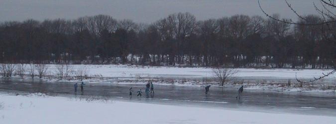
When I lived in eastern Massachusetts, near Boston, several of my colleagues at work shared my love of skating. One of us had speedskates; the rest (including me) had hockey or figure skates. In December and January, we'd drive to the Concord River at lunchtime and skate four or five miles, then eat lunch and go back to work. Between the towns of Bedford and Carlisle, the river is broad and flat, and there are many adjacent marshes and swamps to explore, including portions of the Great Meadows National Wildlife Refuge.
On weekends, I skated longer distances by myself. The Concord River begins at the confluence of the Sudbury and Assabet Rivers in downtown Concord, and it flows northeast to the Merrimack River, which it meets just east of Lowell. I followed the Concord River downstream from Monument Street in Concord (near Old North Bridge) to the North Billerica Dam and back, a distance of about 30 miles round trip. On hockey skates! Heading downstream from Monument Street, the river is narrow and fast-flowing until you reach the Great Meadows on your right.
The Great Meadows are actually a better place to start, unless weather has been very cold and the ice is unusually thick. By car, the Great Meadows are off Route 62 between Concord and Bedford. There are two large ponds, separated from the river by dikes, where you can skate if the river ice turns out to be too thin.
At the Great Meadows, the channel broadens, the current slows down, and the best ice begins. An unbroken series of marshes and swamps line the south bank. In about two miles you reach the Route 225 bridge between Bedford and Carlisle. There's a boat ramp in Bedford on the east side of Route 225, which is another good starting point.
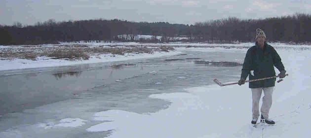
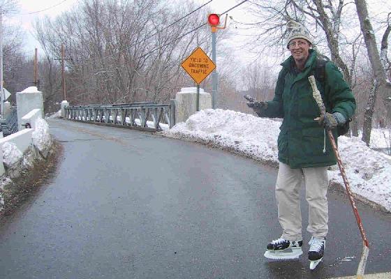
My favorite sections of the river are from Great Meadows downstream to Route 225, and from Route 225 downstream to Route 4. The best strategy is to skate one section at a time, to avoid crossing any bridges. The reason? Usually, the ice isn't safe under the bridges. You have to get off the ice and either climb over the rocks along the bridge abutments, or climb up the bank and walk across the pavement.
To achieve my goal of skating from Concord to North Billerica, I had to first cross the Route 225 bridge, then the Route 4 bridge on the road to Chelmsford, then the twin spans of the Route 3 expressway, then in rather quick succession, bridges at River Street, Route 3A and Pollard Street. I turned around just short of the North Billerica dam, where what's left of the old Middlesex Canal crosses the river on its way from Cambridge to Lowell. I then repeated all the same bridge crossings in reverse order to return to Concord. It's not a trip I'm eager to repeat all in one day. But I would happily return to skate one section at a time.
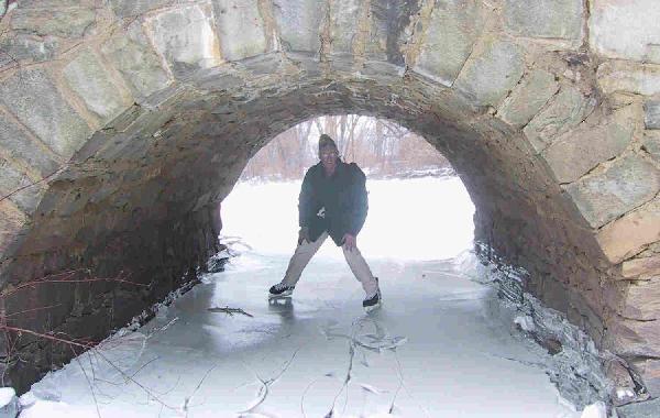
The Sudbury River, a tributary of the Concord, rises in the Framingham area and flows north to Concord Center, where it joins with the Assabet River to form the Concord River. I fantasized skating from the Sudbury River directly onto the Concord River, but that's a dream that will never become reality, because through Concord Center both rivers are narrow, the current is fast, and the water never freezes. So I met the Sudbury River at the Sudbury Road bridge on the south side of Concord, and skated upstream -- heading south -- through Sudbury and Wayland to the Framingham town line and back, a 20-mile round trip. The highlight of this trip is the initial section, from Sudbury Road to Route 117, where the river opens up into a broad lake known as Fairhaven Bay, with impressive mansions sitting atop the bluffs ringing the bay. As on the Concord River, there are many bridge crossings to negotiate, and getting off the ice is mandatory -- especially at the Route 117 bridge, an ancient hump-backed stone structure where even if there is ice, the bridge is so low that you'll have to crawl through on your hands and knees.
South of Route 117, the Sudbury River meanders wildly through the southern segment of the Great Meadows Wildlife Refuge, a scenic undeveloped area. The channel is bordered by extensive marshes on both sides, and if the marshes aren't snow-covered, they'll have good ice too. The next bridge, at Lincoln Road (also known as Sherman's Bridge Road), isn't for a couple of miles. The river continues to meander through the Great Meadows as you skate upstream from Sherman's Bridge to Old Sudbury Road (Route 27). But once you cross Route 27, the channel straightens out, the current picks up speed and the riverbanks are more developed. You'll see Raytheon's giant manufacturing facility across the marshes on the Wayland side of the river, and you'll encounter three more bridges in quick succession: Boston Post Road (Route 20), the railroad bridge and the Pelham Island Road bridge. There is likely to be open water in the middle of the channel, and if there is, you might see ducks, geese, or herons taking flight in advance of your approach. But the presence of waterfowl is a clear warning that the ice is probably unsafe ahead. Eventually the current becomes too strong for ice to form, and you must turn around.
Text copyright © 1998-2006 by Jamie Hess. All rights reserved worldwide.
Comments? Send Email